|
Home |
Who Are We |
Finance Companies |
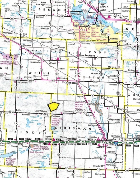
North Dakota Map
80 Ac Stutsman Land For Sale
Lowery Township, Woodworth, Stutsman County, North Dakota
Here's an Affordable Opportunity! Located South of Hwy. 44 in NW Stutsman County, along a Prairie Trail w/55 Ac of 43 PI Grassland. No Ag Leases. Natural Habitat with a Good Stand of Grass, Balance in Herbaceous Wetlands and Open Water presents nice Pasture or Hayland and outstanding Waterfowl, Upland Game and More with a gentle rolling Landscape in the Heart of the Prairie Pothole Region and Migration Flyway. Cropland borders the North edge, surrounded by Pasture. Seller's Asking $79,800 or $998/ac avg.
*********************************
Legal Description: S1/2 SE1/4 of Section 35, Township 144 North, Range 69 West, Stutsman County, North Dakota as described on Abstract including all Minerals currently owned, if any.
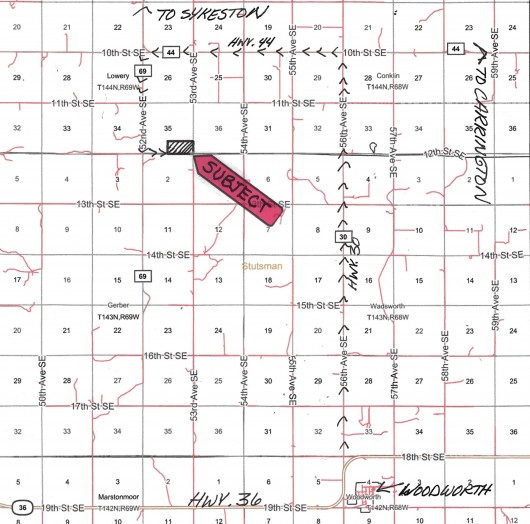
Location: From Jamestown, ND travel 30 Mi W on I-94 to Medina, ND. Turn N on Hwy. 30 for 20 Mi to Woodworth, ND. or From Jamestown travel N on Hwy. 281 towards Carrington. Turn West on Hwy. 36 and travel to Woodworth, ND. Continue traveling N on Hwy. 30 (N of Woodworth) for 8 Mi to Hwy. 44. Turn West and travel 4 Mi to 52nd Ave. SE aka County Road 69. Turn S 2 Miles and then East 1/2 Mi on Section Line Prairie Trail to SW corner of Subject Land. (See Maps)
Acreage Breakdown:
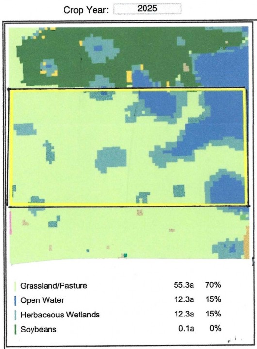
55. 3 Ac of Grassland/Pasture Grass. 12.3 Ac of Herbaceous Wetlands. 12.3 Ac of Open Water.
Easements: There are NO USFW Grassland Easements on this Land. However, there IS a USFW Wetland Easement that does not interfere with Agriculture or Grazing but does restrict Burning, Draining, Leveling or Filling of Wetlands without permission. This is a perpetual Easement and the Sale is Subject to the new Owner honoring this Easement of Record.
Annual Income: There are NO Ag Leases or Income Earning Programs on this Land.
Real Estate Taxes: Most Recent Real Estate Taxes available are $433.17/year or $5.41/ac avg. which includes 5% Discount for payment by February 15th.
Note: Please check back for Drone Video & Photos when weather permits. Thank you.
Seller's Asking: $79,800 or $998/ac avg.
SALE PENDING!
Plat Map with each square = 1 Mile
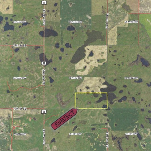
Aerial Map of Subject Land Outlined in Yellow
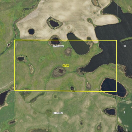
Full View of Section 35 w/Subject Land Outlined in Yellow
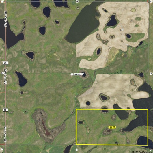
Subject Land Outlined in Yellow showing Surrounding Areas
Crop History showing Acreage Breakdown of Subject
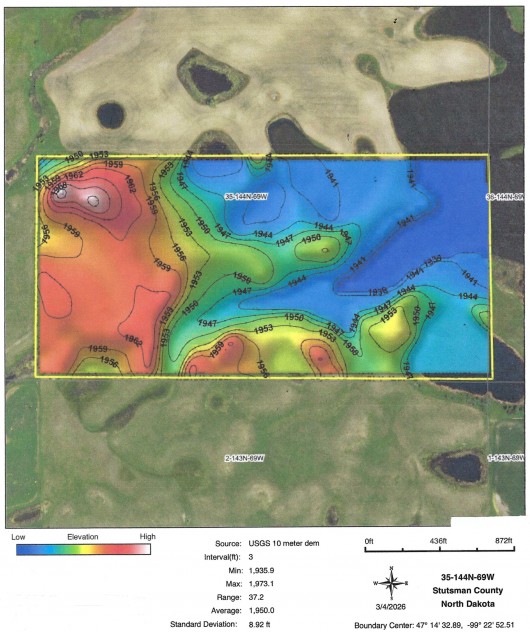
Hillshade Topography Map of Subject showing Gentle Roll
Soil Map and Legend of Tillable Land on Subject
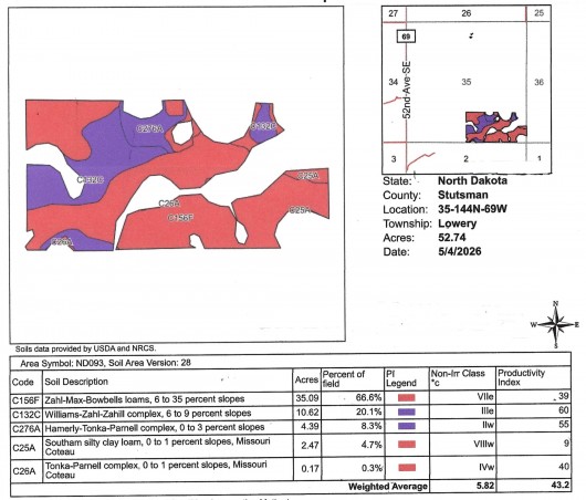
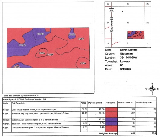
Soil Map & Legend of Full 80 Acres
If you are interested in this property, please contact Prairie Rose Realty Inc. at landbroker@bektel.com or call 701-475-2784 or toll free 800-728-7558.
Prairie Rose Realty Inc. is representing the Sellers in this transaction. All information has been gathered from sources considered reliable, however cannot be guaranteed by Prairie Rose Realty Inc.
|